Games - Matching MC Drop Droplet Process
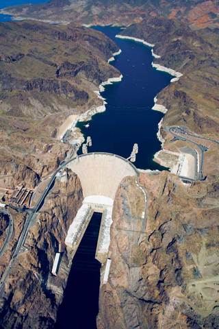
What is this structure?
The large concrete structure shown here is the Hoover Dam, in Nevada. The dam was built to control water flow along the Colorado River. Notice the large reservoir, Lake Mead, behind the dam. Freshwater from Lake Mead is used for recreational purposes, drinking water, irrigation, and hydroelectric power. Dams can also have negative effects on the environment and the ecosystem around a river.
Launch Lab: How can you measure the health of a stream?
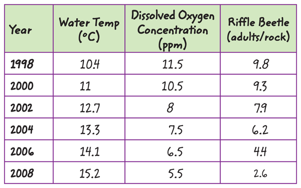
The quality of the water in a stream affects the organisms that live in the stream. Macroinvertebrates are tiny animals without backbones. Their presence can be used to determine the health of a stream. For example, the riffle beetle is only in streams where dissolved oxygen is high and the stream is healthy. Use the data to measure the health of a stream near a new housing development.
1. Read and complete a lab safety form.
2. Use graph paper and colored pencils to construct a graph using the data provided.
3. Plot the water temperature, dissolved oxygen, and the population density for each year represented.
Think About This
1.What is happening to the stream?
2.Make a prediction about the number of adult riffle beetles per rock in 2015.
3. Key Concept Other than a decrease in oxygen, what else might affect the riffle beetle population in this stream?
Runoff
If you’ve ever been outside during a heavy rain, you might have noticed sheets of water rushing downhill over pavement or soil. Water can follow many different paths during a rainstorm. Some water soaks into soil. Some water collects in puddles that evaporate.
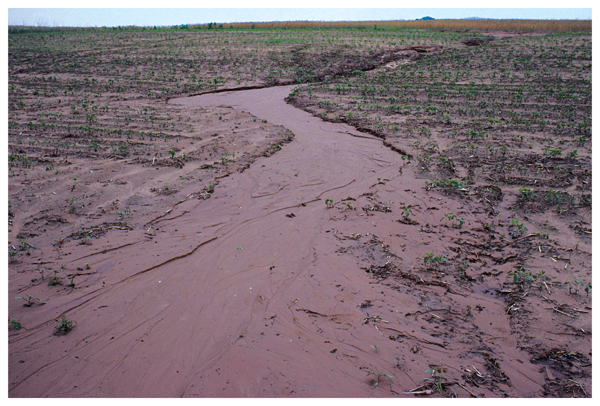
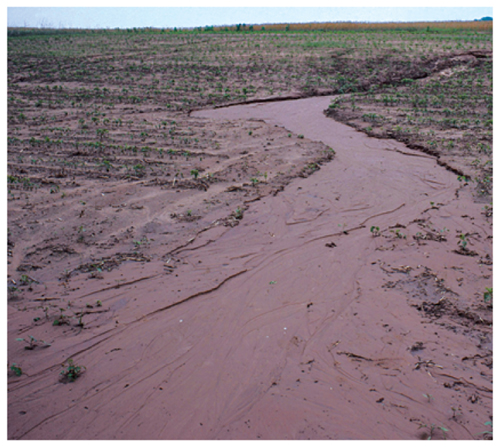
Water that flows over Earth’s surface is called runoff. It comes from rain, melting snow or ice, or any water that does not soak into the soil or evaporate. Runoff is part of the water cycle. Gravity causes runoff to flow downhill, from higher ground to lower ground. Runoff usually starts as a thin layer, or a sheet, of water flowing over the ground, such as the runoff shown in Figure 1.
1.  Reading Check What is runoff?
 Reading Check What is runoff?
Figure 1 Runoff often starts as sheets of water that flow downhill.
Streams
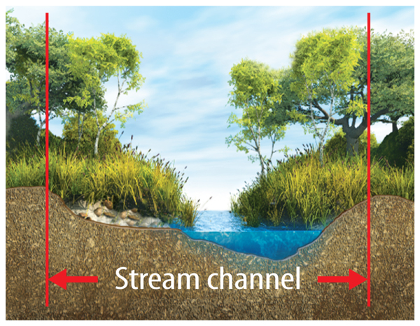
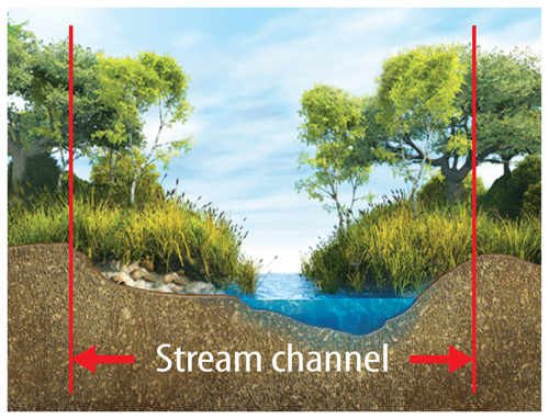
A body of water that flows within a channel is a stream, as shown in Figure 2. Scientists use the term stream to refer to any naturally flowing channel of water. For example, a river is a large stream. A brook is a small stream. A creek is larger than a brook but smaller than a river.
1. Key Concept Check What is a stream?
All streams form from similar processes. As water flows downhill, it wears away rock and soil, forming tiny channels called rills. Every time it rains, more rock and soil is removed from a rill. Eventually a rill grows in size and forms a larger and more permanent stream channel. Small streams can combine and form a larger stream. Large streams can eventually become rivers that flow into a lake or an ocean.
Pools and Riffles
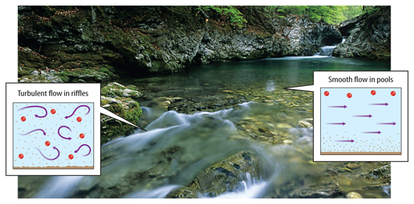
If you’ve ever watched a small stream, you might have noticed differences in the way the water flows. Sometimes the water appears smooth, and sometimes it’s turbulent or rough, as shown in Figure 3.
The water is slow, steady, and smooth in places where the stream channel is flat. Pools often form in depressions or low spots within a stream channel. Where the stream channel is rough or the slope is steep, the water tumbles and splashes. A riffle is a shallow part of a stream that flows over uneven ground. Riffles help mix water as it splashes and swirls over rough areas. This action increases the oxygen content of the water and makes the stream healthier.
Figure 3 Oxygen from the air mixes into water as it passes over riffles. Water from riffles helps supply oxygen to the pools downstream.
Watersheds
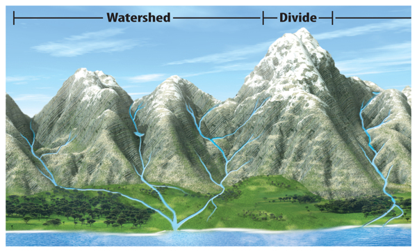
Imagine a house with a roof that is higher in the middle than at its edges. Rain falls on both sides of the roof and runs downward. However, rain runs down the roof in opposite directions. The same thing happens when rain falls to Earth. The direction in which runoff flows depends on which side of a slope the rain falls. A watershed is an area of land that drains runoff into a particular stream, lake, ocean, or other body of water.
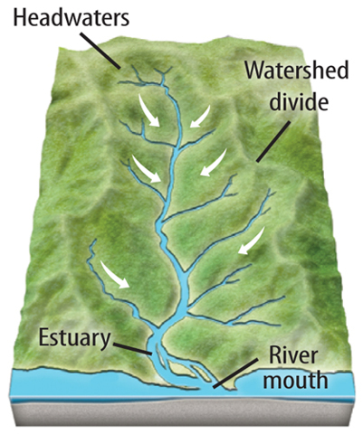
Like the example described, the boundaries of a watershed are the highest points of land that surround it. These high points are called divides. Figure 4 shows examples of watersheds and divides.
2. Key Concept Check What is a watershed?
Figure 4 This watershed includes several streams. They flow into a river, which flows into the ocean.
From Headwaters to Estuaries
Small streams that form near divides are called headwaters. Streams begin at the headwaters. Streams end at the mouth of a river, where runoff drains into a lake, an ocean, or another large body of water.
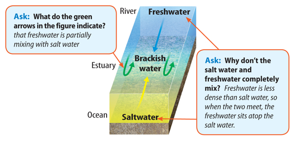
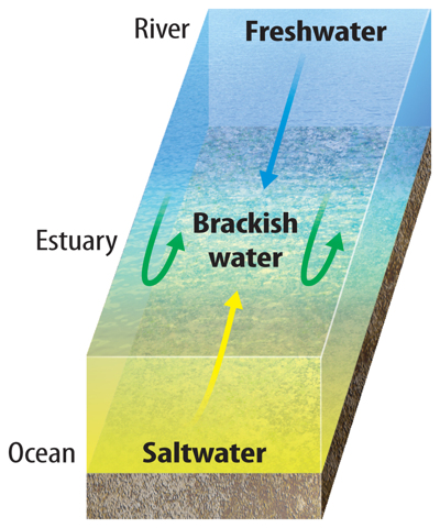
What happens when a river meets the sea? Freshwater mixes with salt water. Many large watersheds end in an estuary—a coastal area where freshwater from rivers and streams mixes with salt water from seas or oceans. Estuaries contain brackish water—a mixture of freshwater and salt water.
As Figure 5 shows, the water in an estuary gets saltier as it gets closer to the ocean. Estuaries are rich in minerals and nutrients and provide important habitats for many organisms.
WORD ORIGIN
estuary
from Latin aestuarium, means “a tidal marsh”
from Latin aestuarium, means “a tidal marsh”
Lakes
When runoff flows into a basin, or a depression in the landscape, a lake can form. A lake is a large body of water that forms in a basin surrounded by land. Most of Earth’s lakes are in the northern hemisphere. Over 60 percent are in Canada. Lakes are reservoirs that store water. Most lakes contain freshwater.
How Lakes Form
Erosion, landslides, movements of Earth’s crust, or the collapse of volcanic cones can form lake basins. Water can enter a lake basin from precipitation, streams, or groundwater that rises to the surface. Most lakes have one or more streams that remove water when the lake overflows. Lakes also lose water by evaporation or when lake water soaks into the ground.
The water level in a lake is not constant. If the lake loses water to evaporation, the lake level will drop. Occasionally a lake will disappear entirely if precipitation does not replenish water lost from the lake. In contrast, if the lake receives too much rainfall, the water can spill over the lake banks and cause a flood.
Properties and Structure
Water changes temperature more slowly than land changes temperature. This can affect weather conditions near the lake. For example, on a hot summer day you might be refreshed by a cool breeze blowing across a lake.
Have you ever been swimming in a lake and noticed that the water changes temperature with depth? Sunlight heats the surface layer, making it warmer and less dense than the layers below. Less sunlight is absorbed the deeper you swim. Some deep, northern lakes develop two distinct layers of water—a warm, top layer and a cold, bottom layer. The two layers are separated by a region of rapid temperature change called the thermocline. It acts as a barrier and prevents mixing between the layers.
SCIENCE USE V. COMMON USE
basin
Science Use a shallow depression surrounded by higher ground
Science Use a shallow depression surrounded by higher ground
Common Use a tub or container used to hold liquids such as water
ACADEMIC VOCABULARY
distinct
(adjective) different or not the same
(adjective) different or not the same
People worldwide depend on streams and lakes for their water supplies. Streams are dammed to create reservoirs that store water. Because of dams, some rivers, such as the Colorado River in the lesson opener, are nearly dry before they reach the ocean.
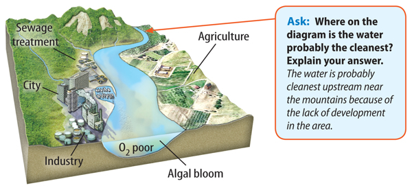
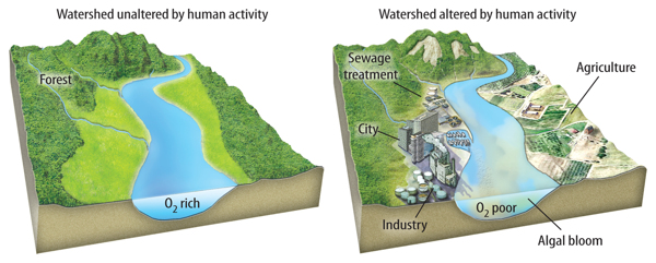
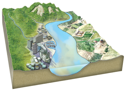
As illustrated in Figure 6, people can affect the health of streams and lakes in many other ways. Runoff can carry fertilizers, pesticides, sewage, and other pollutants that are harmful to organisms living in or near the water. For example, excess nutrients from fertilizers or sewage can enter a stream and result in an increase in the population of algae. When the algae die, bacteria break down the algae and use oxygen in the decay process. If decay rates are too high, oxygen levels in the water can be so low that fish and other animals cannot survive.
1. Key Concept Check How do human activities affect streams and lakes?
Figure 6 Pollutants that flow into freshwater can harm living organisms, including the people who use the water for drinking, washing, and irrigation.
Groundwater and Wetlands
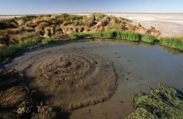
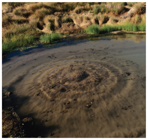
Where did this water come from?
Why is this water bubbling up out of the ground? Have you ever seen anything like it? Groundwater, which is stored in rocks below the surface, can flood the landscape after a severe storm when the ground is saturated. It can also surface in low-lying areas.
Some water that falls to Earth as precipitation soaks into the ground. Generally, water that lies below ground is called groundwater. Water seeps through soil and into tiny pores, or spaces, between sediment and rock. If you have ever been inside a cave and seen water dripping down the sides, you’ve seen groundwater seeping through rock.
1. Key Concept Check What is groundwater?
In some areas, groundwater is very close to the surface and keeps the soil wet. In other areas, especially deserts and other dry climates, groundwater is hundreds of meters below the surface.
Groundwater can remain underground for long periods of time—thousands or millions of years. Eventually, it returns to the surface and reenters the water cycle. Humans interfere with this process, however, when they drill wells into the ground to remove water for everyday use.
Importance of Groundwater
The water beneath Earth’s surface is much more plentiful than the freshwater in lakes and streams. Recall that groundwater is about one-third of Earth’s freshwater. Groundwater is an important source of water for many streams, lakes, and wetlands. Some plant species absorb groundwater through long roots that grow deep underground.
People in many areas of the world rely on groundwater for their water supply. In the United States, about 20 percent of the water people use daily comes from groundwater.
The Water Table
As illustrated in Figure 1, groundwater seeps into tiny cracks and pores within rocks and sediment. Near Earth’s surface, the pores contain a mixture of air and water. This region is called the unsaturated zone. It is called unsaturated because the pores are not completely filled with water. Farther beneath the surface, the pores are completely filled with water. This region is called the saturated zone. The upper limit of the saturated zone is called the water table.
Porosity Rocks vary in the amount of water they can hold and the speed with which water flows through the rock. Some rocks can hold a lot of water and some rocks cannot. Porosity is a measure of rock’s ability to hold water. Porosity increases with the number of pores in the rock. The higher the porosity, the more water a rock can contain.
Permeability The measure of water’s ability to flow through rock and sediment is called permeability. This ability to flow through rock and sediment depends on pore size and the connections between the pores. Even if pore space is abundant in a rock, the pores must form connected pathways for water to flow easily through the rock.
Figure 1 Aquifers store ground water. Groundwater becomes surface water, including springs and streams, in places where the water table meets the surface of the land.
Groundwater Flow
Just as runoff flows downhill across Earth’s surface, groundwater flows downhill beneath Earth’s surface. Groundwater flows from higher elevations to lower elevations. In low-lying areas at Earth’s surface, groundwater might eventually seep out of the ground and into a stream, a lake, or a wetland, as also shown in Figure 1. In this way, groundwater can become surface water. Likewise, surface water can seep into the ground and become groundwater. This is how groundwater is replenished.
Wells People often bring groundwater to Earth’s surface by drilling wells like the one shown in Figure 1. Wells are usually drilled into an aquifer—an area of permeable sediment or rock that holds significant amounts of water. Groundwater then flows into the well from the aquifer and is pumped to the surface.
Precipitation helps replace groundwater drawn out of wells. During a drought, less groundwater is replaced, so the water level in a well drops. The same thing happens if water is removed from a well faster than it is replaced. If the water level drops too low, a well runs dry.
Springs A spring forms where the water table rises to Earth’s surface, as shown in the lesson opener. Some springs bubble to Earth’s surface only after heavy rain or snowmelt. Many springs fed by large aquifers flow continuously.
Human Impact on Groundwater
If polluted surface water seeps into the ground, it can pollute the groundwater below it. Pollutants include pesticides, fertilizers, sewage, industrial waste, and salt used to melt ice on highways. Pollutants can travel through the ground and into aquifers that supply wells. People’s health can be harmed if they drink contaminated water from a well.
The water in an aquifer helps to support the rocks and soil above it. In some parts of the world, water is being removed from aquifers faster than it can be replaced. This creates empty space underground. The empty space underground cannot support the weight of the overlying rock and soil. Sinkholes form where the ground collapses due to lack of sufficient support from below.
3. Key Concept Check How do human activities affect groundwater?
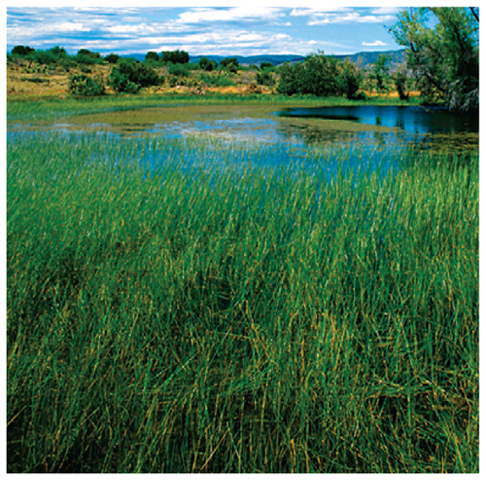
Water often collects in flat areas or depressions that are too shallow to form lakes. Conditions like these can create a wetland—an area of land that is saturated with water for part or all of the year. Wetlands also form in areas kept moist by springs, and in areas along the shores of streams, lakes, and oceans. The water in a wetland can remain still or flow very slowly.
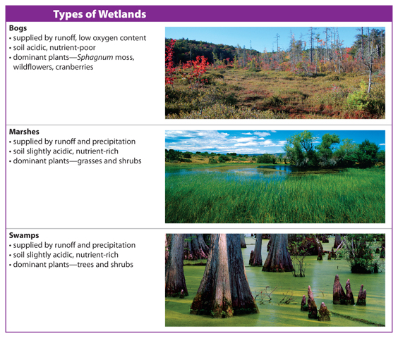
Types of Wetlands
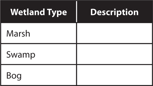
Scientists identify wetlands by the characteristics of the water and soil and by the kinds of plants that live there. There are three major types of wetlands, as shown in Table 1. Bogs form in cool, wet climates. They produce a thick layer of peat—the partially decayed remains of sphagnum moss. Peat holds water, so bogs rarely dry out. Unlike bogs, marshes and swamps form in warmer, drier climates and do not produce peat. Marshes and swamps are supplied by precipitation and runoff. They can temporarily dry out in hot, dry weather.
Table 1 This table shows and compares three types of wetlands.
Importance of Wetlands
Wetlands provide important habitat for plants and wildlife. They help control flooding and erosion and also help filter sediments and pollutants from water.
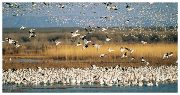
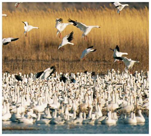
Habitat A wide variety of plants and animals live in wetlands, as shown in Figure 2. Wetlands provide plentiful food and shelter for young and newly hatched animals, including fish, amphibians, and birds. Wetlands are also important rest stops and food sources for migrating animals, especially birds.
Flood Control Wetlands help reduce flooding because they store large quantities of water. They fill with water during the wet season and release the water slowly during times of drought.
Erosion Control Coastal wetlands help prevent beach erosion. Wetlands can reduce the energy of wave action and storm surges—water pushed onto the shore by strong winds produced by severe storms.
Filtration Wetlands help keep sediments and pollutants from reaching streams, lakes, groundwater, or the ocean. They are natural filtration systems. Runoff that enters a wetland often contains excess nitrogen from fertilizers or animal waste. Plants and the bacteria in wetland soils absorb excess nitrogen. Wetland plants and soils also trap sediments and help remove toxic metals and other pollutants from the water.
1. Key Concept Check Why are wetlands important?
Figure 2 Wetlands are an important habitat for wildlife, providing water, food, and shelter.
Human Impact on Wetlands
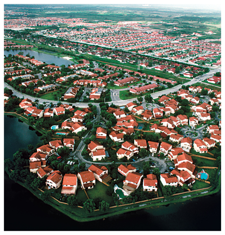
Many wetlands throughout the world have been drained and filled with soil for roads, buildings, airports, and other uses. The disappearance of wetlands has also been associated with rising sea level, coastal erosion, and the introduction of species that are not naturally found in wetlands. Scientists estimate that more than half of all wetlands in the United States have been destroyed over the past 300 years.
The Louisiana coastline has lost about 310 km2 of wetlands since 1950. Figure 3 shows some of the changes that have taken place on the Louisiana coast. A lack of coastal wetlands may have contributed to widespread flooding that occurred when Hurricane Katrina struck the area in 2005.
2. Key Concept Check How do human activities affect wetlands?
Figure 3 Large portions of the coastal wetlands of Louisiana have been filled in to build roads and buildings. Scientists and engineers have proposed that future flooding could be avoided by restoring some wetland areas.
1
WORD ORIGIN
sphagnum
from Greek sphagnos, means “a spiny shrub”
from Greek sphagnos, means “a spiny shrub”
Lesson Review
Visual Summary
Groundwater fills pores in soil and rocks in the saturated zone. The water table marks the top of the saturated zone.
A wetland is an area of land that is saturated with water for part or all of the year.
Human involvement in alteration and destruction of wetlands can have devastating effects.
Frank Krahmer/Masterfile
Water that flows over Earth’s surface and into streams and lakes is called runoff.
Watersheds begin at high places called divides, where headwaters flow downhill.
Humans can have a negative impact on the health of streams and lakes.
Lesson Assessment
Use Vocabulary
1. Use the term runoff in a complete sentence.
2. Define watershed in your own words.
3. Distinguish between a lake and a stream.
A. Distinguish between porosity and permeability.
B. Use the term groundwater in a complete sentence.
C. Define water table in your own words.
Understand Key Concepts
4. Which is the correct order of small bodies of water to large bodies of water?
A. streams, estuaries, rivers,
B. estuaries, streams, rivers
C. rivers, estuaries, streams
D. streams, rivers, estuaries
5. Describe how lakes form.
6. Distinguish between runoff and streams.
7. Explain how divides affect water flow.
8. What causes water to move from areas of higher elevation to areas of lower elevation?
A.erosion
B.thermocline
C.gravity
D.mixing
9. Which statement about watersheds is true?
A.All watersheds are the same size.
B.Larger watersheds can be broken down into smaller watersheds.
C.Watersheds do not go across state borders.
D.Watersheds consist only of surface water.
10. Which statement about lakes is NOT true?
A.Lakes always contain freshwater.
B.Streams flow in and out.
C.They form in a hollow basin.
D.Water temperature varies with depth.
C. Where is the saturated zone located?
A.above the water table
B.below the water table
C.beside the water table
D.within the water table
D. Explain how groundwater can become surface water.
E. Explain how groundwater that is used as drinking water reaches homes.
F. List three reasons wetlands are important to people and the environment.
G. Which is NOT a reason wetlands are important?
A.affect climate
B.control erosion
C.filter out pollutants
D.provide wildlife habitat
Interpret Graphics
11. Summarize Look at the diagram. How is this structure formed?

H. Organize Information Copy and fill in the graphic organizer below to describe the different types of wetlands.

Critical Thinking
12. Synthesize Swimmers dip their toes into lake water, and it feels warm. When they dive in, they
discover that the lake is much colder. Explain why.
13. Evaluate Write a paragraph describing how the destruction of a forest to make room for a factory
could affect organisms in a nearby stream.
14. Illustrate the formation of a stream.
15. Design a model that shows how a lake can form from the movement of tectonic plates.
